Mattawoman Creek, view at the foot of Mattawoman Creek Road
Leader: Steve Palincsar

Members: Ron Altemus, Joan Oppel, Jackie and Randy Schoch, Lou Dall'Orso, Pat Walthers
Route: https://ridewithgps.com/routes/40055263
Weather: Mostly cloudy, humid, some drizzle and light rain. 77-86 degrees. The chance of rain originally was in the single digits, but by noon the chance had risen to 100%. Our first inkling of the change came while making the turn onto Bumpy Oak, when Iwe noticed how dark the sky had become. By the time we reached the Indian Head Rail Trail it was raining, but it was all over by the time we finished loading the cars.
AMS: 12.5
Mechanicals/Mishaps: None
Report: Today's route was intentionally something different. We took Hawthorne to Strauss -- are all those speed humps new? I sure don't remember them -- then rode to the foot of Mattingly for spectacular views of the Mattawoman Creek. Climbing back up to Jennifer we wound through neighborhood streets back to the IHRT, then took Hawthorne to Chicamuxen.
2.2 miles up Chicamuxen we turned onto Mattawoman Creek Road. I'd been there once before, two or three years ago, with Ron and Joan, but for Lou, Pat, Randy and Jackie this was new territory.
You don't get more than a few yards down the road before you could to a big dip, a 30' descent, a crossing of a tributary of the Mattawoman Creek, and an immediate 30' climb. From the bottom of the dip, that 30 foot rise looks like a hundred feet wall and you really have to hurl yourself down to get momentum to help you climb back out. (Unless you have a motor, that is, like me and the Electric Shocks, in which case you set your motor control to Warp Three and power up the slope.) Fortunately, you don't have to negotiate the dip on the way back.
Once past it, it's an easy trip down to the shore. You're met with great views of the Mattawoman Creek looking towards the Indian Head Naval Base.

Mattawoman Creek looking towards Indian Head Naval Facility
Every map in Ride With GPS's route planner but the USGS Scan shows Mattawoman Creek intersecting with Gumtree Swamp Place heading back towards Creeds Mill. The USGS Scan shows it as a jeep track or a footpath, and Bing says it's not there at all.
Bing is right: it's one of those "imaginary roads, " a road that is on the map because there's a right-of-way there, and perhaps it's inn somebody's plan and sometime in the far distant future a road may be built there, but it doesn't actually exist on the ground here and now. It's not the only imaginary road in our area. Don't try to follow Hancock Run Rd from the turn at Adams Willet down to Smith Road. Google Maps says it's there, but ground truth is a gravel driveway that goes no more than a hundred yards before it ends at a fence.
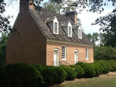
So we backtracked on Mattawoman Creek to the top of the rise and turned right on Creeds Mill and followed it -- with no hill to speak of -- back to Hawthorne, then turned into Smallwood Park. After a rest stop on the shores of the Mattawoman Creek we took a tour of the Historic Area past Smallwood's Retreat, Revolutionary War General William Smallwood's house,

Photo by Maryland Dept of Natural Resources
before exiting the park on the original Sweden Point Road.
We took Sweetman to Bicknell and turned on Ripley, passing the extensive clear cut 187 acres of the MD Solar 2 Ripley Road Project (for more info, see https://go.boarddocs.com/md/chrlsco/Board.nsf/files/CFEMF75AFC9F/$file/Solar%20Farm%20Presentation%206-28-2022%20.pdf ) I only discovered the Ripley Road Solar site riding past it the other day, when I saw the construction portolets and figured it was bad luck to pass two portolets without stopping. Today, I passed three portolets without stopping and got a good passing look at the sites on either side of the road (and look what happened).
By the time I got to the turn for Bumpy Oak the weather had changed and the sky was ominously dark. A mad chase down Bumpy Oak followed, and by the time I made the turn onto the IHRT it was drizzling. Just bad luck, do you think?
