Menu
Log in

Oxon Hill Bicycle and Trail Club

Log in

Ride Reports

Ride Leaders are encouraged to post reports on their rides. Members can comment on ride reports and anyone can read the reports and comments. Instructions for posting a report
<< First  < Prev   1   2   3   4   5   ...   Next >  Last >> 
  • Sun, July 27, 2025 9:00 AM | Ron Altemus (Administrator)

    Leaders:   Joan Oppel off the front; Ron Altemus sweeping

    Members:   Fran Jezisek, Mark Garrison, Bob Rourke, Paul Adams, Joan Oppel, Janell Saunders, Gene Villiva, Steve Palincsar, Susan Altemus.  Not pictured:  Patricia Sanders


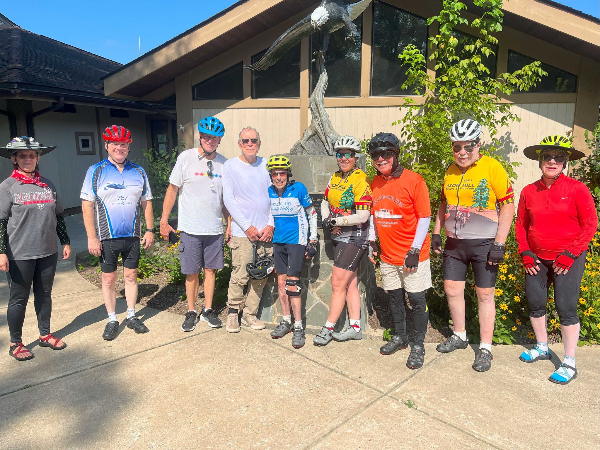
    Route:   https://ridewithgps.com/routes/40798783  27.6 miles, 738' elevation change.  Starting at Gunston Elementary heading east on Gunston Rd, we almost immediately took a right onto Belmont Blvd for a 2-mile jaunt to its end to view the eponymous bay.  Retracing back to Gunston Rd to again head east, within a quarter of a mile we got onto the Mason Neck trail which took us to a short spur on Springfield.  We rejoined the trail and followed it down to High Point Rd which led us to the Mason Neck State Park for the obligatory group photo (above).

    Another retrace back to Gunston Road and again eastward to tours of the Hallowing Point and Gunston Manor neighborhoods.  Whilst riding through the former along River Rd, we were able to identify the three scrub islands nearer to the Maryland shore in line with Mt Aventine off of Chapman's Landing Rd.  Gunston Manor afforded us views of the Potomac River to the north with Mt Vernon barely visible along the tree line.

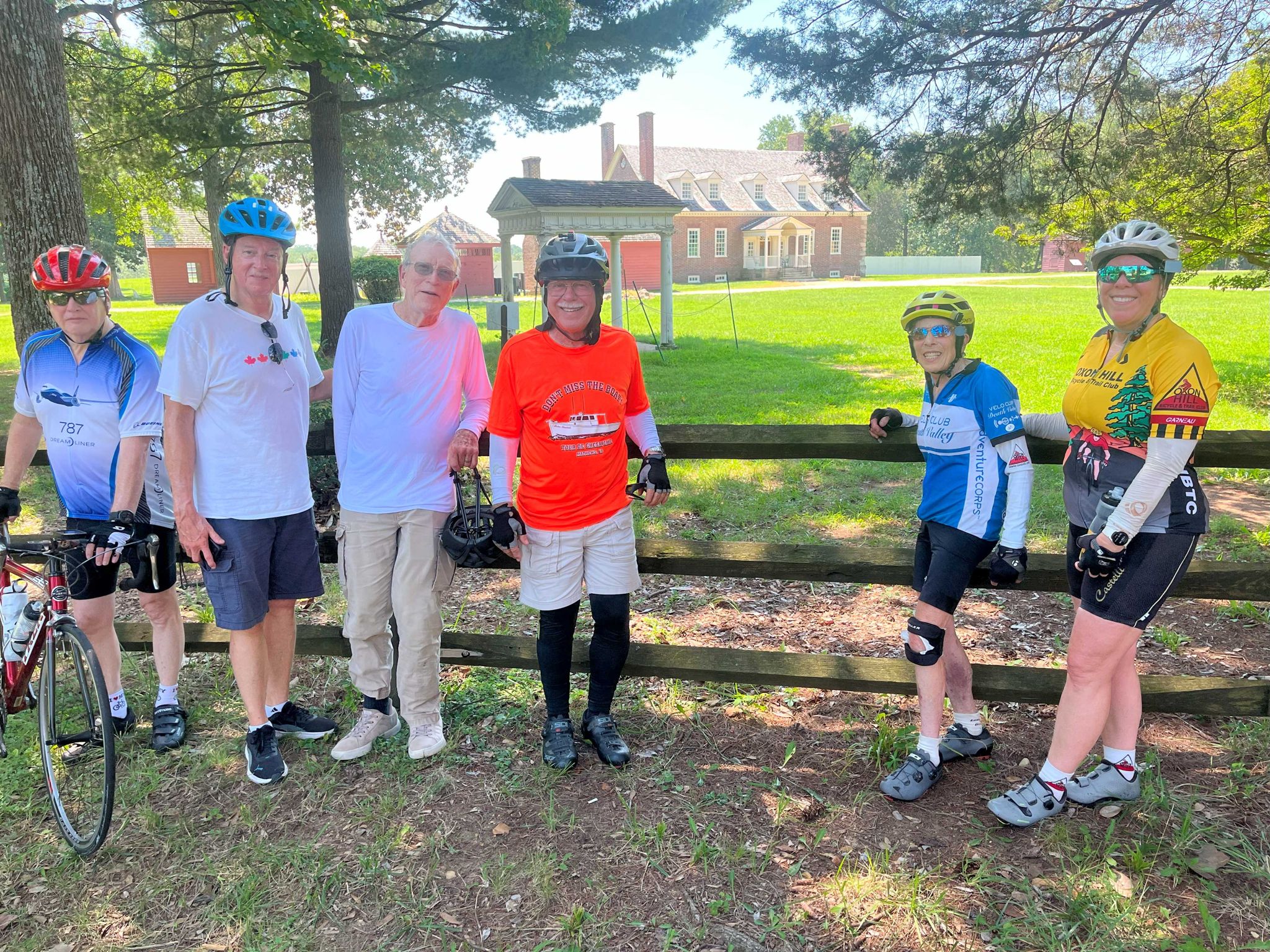
    Our return took us west on Gunston Rd back to the Mason Neck trail.  We did a side trip to George Mason's Gunston Hall (pictured below) and another into Pohick Bay Regional Park (which included a loop through the shaded campground).  Final spur into the golf course was jettisoned as the day had become much warmer.  Most riders still ended with about 27 miles.

    Weather: Sunny, hot and humid: temperatures in the 80s with "feels like" temps as high as 101.  They had a weather alert sign out at Mason Neck park, and although it was comfortable in the shade while we were moving, it was brutal standing still in the sun.

    AMS: upper 11s for many riders; swept in the mid 10s

    Mechanicals/Mishaps:   two separate tumbles, both while not moving, one getting on, one getting off.  The former needed a bandaid but continued for the rest of the ride; the latter's pride was the only thing hurting.

    Report:  a nice turnout including some newish riders to bicycling on the road instead of only trails.   Joan led off the front, stopping at the major turns to allow regrouping.  Gunston Road is the only main artery on Mason Neck but today vehicular traffic was very light.  While sections of the trail were in direct sunlight, Belmont Blvd, Springfield and High Point had copious amounts of shade, feeling 5-10 degrees cooler.

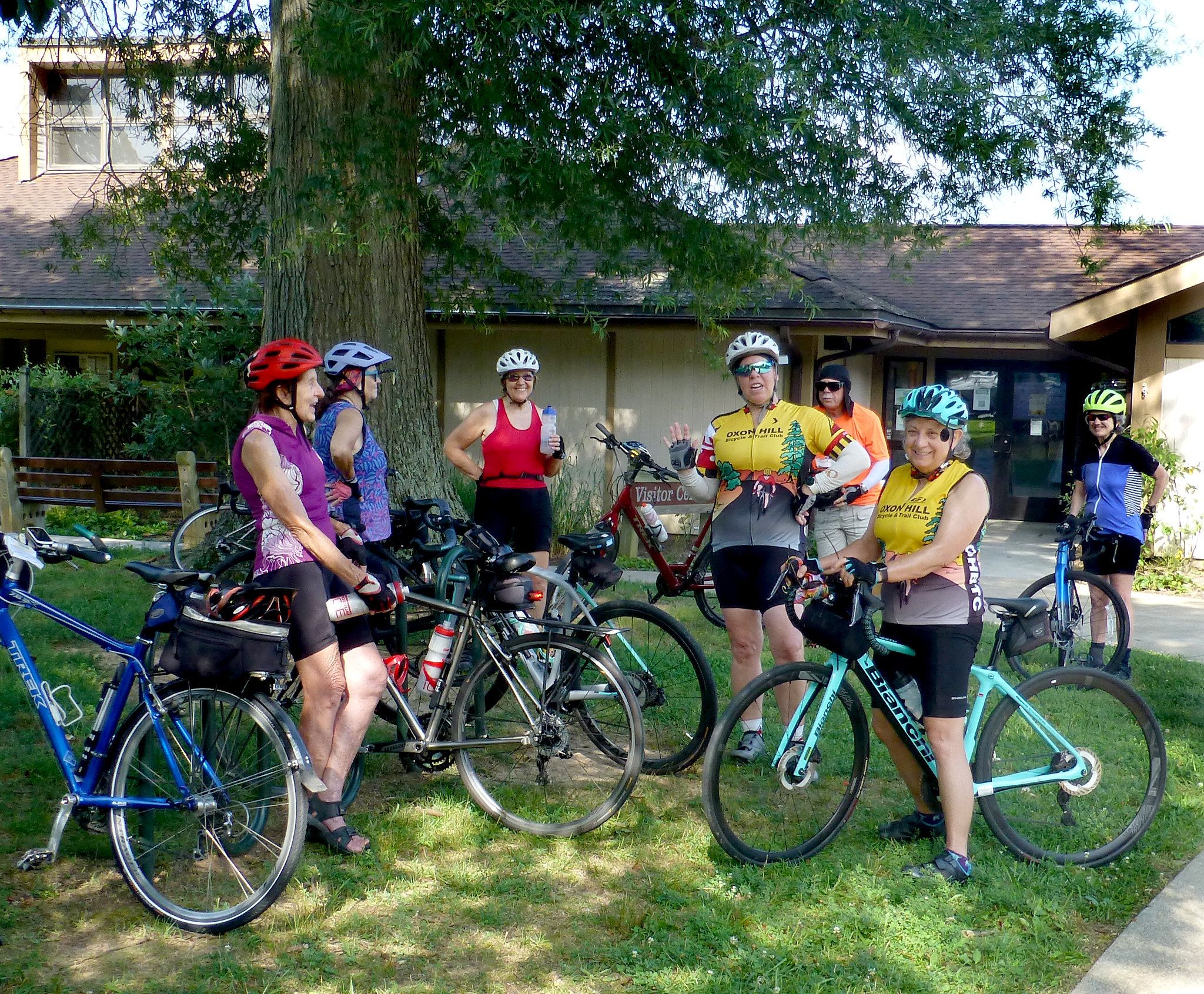
    At our rest stop at Mason Neck, we were joined by PPTC riders that were also riding on the neck today.  They had started a bit earlier than we did to avoid midday heat.  Familiar faces spent a bit of time comparing notes and ride experiences as shown below.  Photo courtesy of Steve Palincsar.


    Following the rest stop, we leisurely rode through the two neighborhoods at the eastern end of the neck, noticing how the older, smaller homes were gradually being replaced by mansions.  Our visit to Gunston Hall allowed an opportunity to view one of the oldest homes on the neck.  Thankfully, we don't have to worry about it being torn down.

    No wildlife sightings today.  Maybe too hot to venture out into the sunlight, especially since it was much nicer under the tree canopy shade.

  • Sat, July 26, 2025 9:00 AM | Stephen Palincsar (Administrator)


    Giants visiting the Sprite House on Stuckey Rd.  Sprite was not at home.  

    Leader: Steve Palincsar


    Members: Joan Oppel, Ray Luckenbach, Harry Kidd, Tom Short, Dave Van Amayden

    Route: https://ridewithgps.com/routes/40019673  31 mi, 1230' elevation gain.  Mason Springs and Ironsides to Durham Church; down Durham Church and right on 6, up Annapolis Woods and back down to 6 on Fire Tower, Mill Swamp, Blossom Point and Brentland to Goose Bay.  After the break, up Blossom Point, 6 to Burch, left on Poorhouse, Stuckey Rd & Ln to Mason Spring and Pisgah Marbury, left on Bicknell back to Mason Springs and right to Pisgah Park.

    Weather: Sunny, hot and humid: around 80 at the start and 90 at noon, humidity 70% to 60%, 7 mph breeze.

    AMS: 13.5

    Mechanicals/Mishaps: none

    Report: A hot day, but a mostly shady route and a nice breeze made it bearable, even pleasant, as long as we were moving or stopped in the shade -- and we did stop in the shade, often, and not just to regroup but also to enjoy the delicious coolness. 

    Durham Church and Mill Swamp were exceptionally beautiful today due to the contrasting light and shadow, and the Sprite House stop on Stuckey (a battery swap for me, unfortunately out in the sun, as well as an obligatory photo op) was a shady treat.

    Normally, 30 miles wouldn't be much of a ride for mid-season, but with the weather we're having this summer, it was just about right (where "just about right" is defined as "much more and we would have flopped right down and fallen on our faces before the end").

  • Sat, July 26, 2025 9:00 AM | Anonymous member

    Leader:  Lou Dall'Orso

    Members:  None

    Guests:   None

    Route:   https://ridewithgps.com/routes/51830450

    Weather:  Around 80 at start, almost 90 by the end, humid and nary a cloud.

    AMS:   16 MPH

    Mechanicals/Mishaps:   None

    Report:  Plan was to ride the first 5 miles or so with the CC group at the 0900 start time, as we shared the same route to that point, but because of the expected heat, took a poll, and everyone signed up for this ride agreed to get going when ready, which was around 0830 give or take.  The route took us down Mason Springs, Iron Sides, Route 6, Riverside, Chickamuxen, and ending with a right on Mason springs for a straight shot back to Pisgah Park. Took another poll to see if anyone would like to add 4 miles or so by way of Hawthorne to Ripley, to Poor House, to Mason Springs, but by decision time the heat and humidity made it unanimous to stick to the plan. In addition to the very shady roads of Riverside, there was shade on several of the other roads, particularly on Chickamuxen, so I think we will stick with Clockwise until the weather relents, as the shade makes a significant difference particularly later on in the day. 
  • Fri, July 25, 2025 9:00 AM | Ron Altemus (Administrator)

    Leader:   Ron Altemus

    Members:   Bob Rourke, Gene Villiva, Susan Altemus, Robin Garnett, Fran Jezisek, Connie Quikstad, Donaro Gardner, Mark Garrison, Esther Stewart, Paul Adams, Carl Hattery


    Route:   where else to ride on a Friday morning but the Indian Head Rail Trail - Livingston Rd parking lot east to White Plains trailhead and return

    Weather:   sunny, marginal breezes, temp range low 80s to upper 80s, humidity very noticeable

    AMS:   swept in the mid 11s

    Mechanicals/Mishaps:   none known

    Report:  thankfully, the earlier 9 am start had us finishing while the dew point was only in the muggy range and hadn't reached "oppressive."  In addition to our gang, trail users included walkers, a few runners, and numerous other cyclists.  Not much in the way of wildlife today:  minimal number of turtles in some of the ponds, a black vulture overhead (perhaps hoping someone would succumb to heat stroke?), and a few butterflies.

  • Thu, July 24, 2025 9:00 AM | Stephen Palincsar (Administrator)

    At Whites Landing

    Leader: Steve Palincsar

    Members: Denny Miller, Joan Oppel, Tom Short, Sonja Newman, Harry Kidd, Patricia Walthers and Lou Dall'Orso

    Guests: none

    Route: https://ridewithgps.com/routes/32110645  33.8 mi, 2043' elevation gain. 

    Weather: Sunny, hot and humid: low 80s at the start rising to just about 90 by early afternoon, 60% humidity and winds ranging from 10-15 mph.

    AMS: 12.4 mph

    Mechanicals/Mishaps: none

    Report: A scenic route with lots of shade and, as it turns out, lots of elevation gain: hard enough that for some the awareness of the scenic surroundings didn't become evident until well into the ride due to the challenging nature of the terrain. 

    One of several breaks in the shade: here at Brooks Church, after the climbing on Baden Naylor

    The shade and the breeze made it seem so cool, so pleasant, especially on the downhills that I really didn't notice the temperature until we'd arrived back at North Keys Park; and I didn't notice the effect of the temperature until the Man With the Hammer came for me on the drive home.

  • Wed, July 23, 2025 6:00 PM | Sonja Newman


    Leader: Sonja Newman

    Members: Lou D. and Connie Q.

    Guests: none

    Weather: Low Humidity, Sunny

    AMS:  11 - 12 mph

    Mechanicals/Mishaps: none

    Report: 

     There were three of us  - Lou, Connie and myself - out for a beautiful evening ride. The weather couldn't  have been better clear skies, low humidity, and comfortably warm temperatures. Lou rode his bike to meet us at the starting point, and from there, the three of us set off at a comfortable pace, riding together most of the way. 

    The descent down Marshall Hall was a thrill - Fast and Furious-style! Connie surprised me by staying close behind; later, she mentioned feeling faster today, and I'd have to agree.

    At the halfway point, we paused at the rest stop over looking the Potomac River. We snapped a few photos and took in the view. I even spotted a couple of adults and two kids in the water.

    As we approached the final mile, Lou picked up the pace, making a break for home before the sun dipped below the horizon. 

    Lou thanks for  sticking with us for the whole ride!  

    All in all, it  was a great ride with good weather, great company, and strong vibes.

    Here's to the next one!


  • Sun, July 20, 2025 9:00 AM | Stephen Palincsar (Administrator)

    Leader: Steve Palincsar

    Members: Anonymous User, Lisa Oken, Janell Saunders, Joan Oppel, Pat Colvin, Linda Bankerd, Patricia Sanders, Sherwood Byers and Ron Altemus

    Guests: none

    Route: https://ridewithgps.com/routes/26920630  28.2 mi, 696' elevation gain

    Weather: Hot and humid, what else?  The day started off overcast, but by the time we reached the rest stop at Marshall Hall, what is usually a pleasant oasis was more like inside that device you see in a 7/11 where the hot dogs rotate, sweating out their grease as they slowly turn.

    AMS: 12.2

    Mechanicals/Mishaps: none

    Report: We started out together, but by the time we reached the turn onto Fenwick we were strung out.  Some skipped Fenwick and stayed on Marshall Hall, others were on the way back. 

    After a very pleasant trip down a meandering wooded lane with views of the Potomac we reached the end of Marshall Hall Rd.  Out in the sun it was too hot to take a rest stop there there, so those of us not already on the way back stopped in the shade at the end of Riverside for a break.

    Some in the group had never been on Fenwick and Riverside, and really enjoyed the surprising rural seclusion and, of course, the shade.   It's always a treat to show riders these hidden delights for the first time.

    Back in the cool of the shade on Barrys Hill and left on Old Marshall Hall, those of us who hadn't already come and gone and those who skipped the out-and-back, stopped at the Welcome sign for a photo op before heading back to the Firehouse, arriving, as promised, by noon.


  • Sat, July 19, 2025 9:00 AM | Stephen Palincsar (Administrator)

    Leader: Steve Palincsar

    Members: Deb Bowman, Patricia Sanders, Lou Dall'Orso, Joan Oppel, Tom Short, Patricia Walthers and Harry Kid

    Guests: none

    Route: https://ridewithgps.com/routes/51732149

    Weather: Overcast, cloudy, sometimes sunny, sometimes heavy dark clouds; very humid, temperatures in the 80s.  Seemed like there was rain all around us, including recently rained-on roads, but other than a few stray drops that could have been blown in the wind, we avoided the rain.

    AMS: 13.8

    Mechanicals/Mishaps: None.

    Report: We could call this route "McKendree Detour #1," probably the first of many variations working around the closure of McKendree Rd between now and next spring.  Today we took Pindell and Wrighton to Bay Front and rode it, pleasantly surprised at how much shade there was, all the way to MD-2, then took Old Solomons and MD-2, again very happy to see how much shade, to a right on the official detour route on Jewell to Wilson and Sansbury.  A bit of a wait at the rotary, then across and down Walke at the restaurant to Old Solomons, past the Christmas tree farm to a rest stop at the Dash-In.

    Climbing back past the tree farm after the break, we turned on Friendship and Boyd's Turn, then went left on 5th st into North Beach.  As you'd expect with this group of riders, we split into a fast group and a not so fast group with the occasional regrouping stop.  At North Beach the fast group didn't stop for the photo op, but rather went straight to Chesapeake Market under heavy dark clouds that looked as though we'd be rained on any second.

    After a brief stop at the Market we climbed up Friendship and went down Fairhaven on to Town Point -- a bit of a running stream across the road, but not a huge pond like last time, when a rider went down in the water -- and up Leitch.  We regrouped at the top of the climb, then went left on Franklin Gibson back to Fairhaven Rd, right on Old Solomons, then pm MD-2 back to Bay Front for half a mile, right on Brooks Woods and another rest stop at Honey's Harvest Farm.  The Farm Store was open today, and after a visit to the store we debated route changes due to the very dark cloud right overhead and the occasional sprinkle. Since the next few miles had no alternatives, we decided to defer a decision on short cuts until we got to Southern Maryland Blvd at Lothian. 

    It had obviously rained on Brooks Woods, and only moments before, but as we headed towards Lothian the sky cleared and the sun came out.  Forget the short cut: we all took the full route, Southern Maryland Blvd to Upper Pindell to Pindell, Plummer Lane and the MD-4 Service Road back, for a full 46 miles.

    Unpromising weather yielded a comfortable ride, and a forced detour that put us on unfamiliar roads in seldom-ridded directions turned out to be a very pleasant route, and a worthy alternative to our more-frequently used variations.


  • Fri, July 18, 2025 9:00 AM | Jackie Schoch

    Leader:  Jackie Schoch

    Members:  Bob Rourke, Paul Adams, Ron & Susan Altemus, Fran Jezisek, Robin Garnett, Mark Garrison, Carl Hattery, Janell Saunders, Esther Steward, Gene Villiva 

    Guests:  Jennifer Wampler from Richmond, VA.

    Weather:  The weather was nice and cloudy but the sun came out toward the end, since the Ride Leader Jackie forgot to put on suntan lotion and got burned.

    Mechanicals/Mishaps:  Paul Adams had a little problem with his new electric bike when he went to shift gears.  The problem wasn't electronic, it was his chain fell off. Easy fixed.

    Report:  It was another Friday with a GREAT turn out.  We saw a deer, turtles at the beaver dam and of course squirrels.  It was great having Jennifer Wampler from Richmond, VA and she is a volunteer for the Potomac Heritage Trail.  She said it took her 1 hr 45 mins to get to the ride.  She said that she had heard a lot about our Bike Club.  I told her how we got started and that we are 53 years old.  After our ride Ron and I took her to the beginning of the trail.  She loved our IHRT.  Jennifer told us there will be a meeting open to the public at the St. Mary's Library in Leonardtown about  joining the Three Notch Trail and the IHRT Trail in October.  I am sure we will get more information about this.

    Image


    Image

  • Thu, July 17, 2025 1:25 PM | Sonja Newman


    Four of us - Tom S, Steve P, Patricia S and I - set out on a leisurely bike ride that began on mostly  shady roads, offering a comfortable and scenic  start. We all stayed together at a relaxed pace as we made our way to the first rest stop at St. Ignatius. The climb up St. Ignatius hill was tough, but the view and a sense of accomplishment made it worthwhile. While  we rested, Steve took some photos and mentioned he was on the lookout for butterflies. 


    After a brief stop at our second rest point, The Dash In gas station, we began our return back to the starting point. Roughly 6 or 7 miles out Steve got a flat tire. Pat and I assisted  - though the first inner tube didn't hold, the second one did the trick. 

    A kind couple couple stopped to check if we needed help, but unfortunately, they didn't have a suitable bike pump.

    The final stretch - over four miles on a the Indian Head Trail - was especially refreshing. Tom initially unaware of the flat, had gone ahead. Pat gave him a quick call and he graciously waited for us at the parking lot to wrap up a great day of riding!

<< First  < Prev   1   2   3   4   5   ...   Next >  Last >> 

Oxon Hill Bicycle and Trail Club
P.O. Box 81  
Oxon Hill, MD 20750-0081

Patuxent River Rural Legacy Bicycle Ride Be a volunteer
Powered by Wild Apricot Membership Software